
Overview
Relevant Activities
Role of Local Governments
U.S. EPA Resources
Other Resources
States
Other Federal Agencies & Programs
Funding & Financing
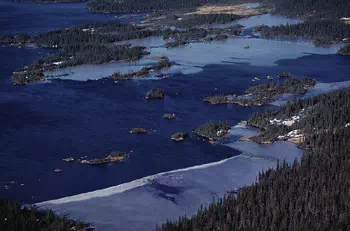
The term watershed refers to the geographic boundaries of a particular waterbody, its ecosystem and the land that drains to it. A watershed also includes groundwater aquifers that discharge to and receive discharge from streams, wetlands, ponds, and lakes. Large watersheds are sometimes referred to as river basins.
- Precipitation Management & Preparation
- Bridges, Roads, and Other Infrastructure Construction & Maintenance
- Transportation Planning, Operation, and Management
- Public Land Management
Watershed protection/restoration is accomplished through efforts at various levels including EPA, state agencies, local agencies, and private organizations. In most cases watersheds do not conform to political boundaries and, therefore, effective solutions require cooperative efforts.
States are required, under the Clean Water Act, to develop lists of impaired waters. Impaired waters are those that are too polluted to meet specified water quality standards. The law requires that states establish priority rankings for waters on the lists and develop total maximum daily loads (TMDLs) for these waters. A TMDL is a calculation of the maximum amount of a pollutant that a waterbody can receive and still meet water quality standards.
The EPA has encouraged states and others to develop watershed plans to help protect and restore our waters. Watershed planning helps address water quality problems in a holistic manner by assessing the potential contributing causes and sources of pollution, then prioritizing restoration and protection strategies to address these problems. A watershed plan provides an analytical framework for managing efforts to restore water quality in degraded areas and protect overall watershed health. Many communities across the country struggle to find the right approaches, tools, and data to include in their watershed plans. The complexity and diffuse nature of pollution, the costs of restoration and remediation, and the need to achieve voluntary action by individual landowners can require years of support from a coalition of stakeholders, programs, and funding sources.
U.S. Environmental Protection Agency Resources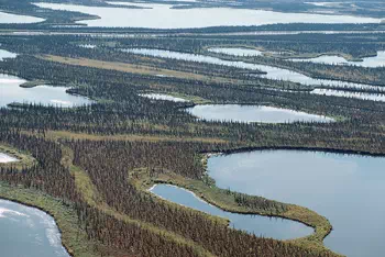
- How's My Waterway? Interactive data tool to learn more about the water quality of community, state, and national waterways. Includes information on swimming safety, health of aquatic life and drinking water safety.
- Watershed Academy. A free set of webinars, educational modules and publications that provide an introduction to watershed management.
- Sanitary Survey. An app that helps waterbody managers evaluate all waterbody and watershed information including water quality data, pollution source data, and land use data.
-
Environmental Justice and the CWA 303(d) Program: Practices and Ideas from Conversations among State, Territorial, and Tribal Staff (2022). ELI report on how states, territories and Tribes incorporate practices that consider environmental justice into their water quality programs, particularly CWA 303(d) programs.
-
Total Maximum Daily Load Resource Locator (TMDL). Use this tool to find out more about the TMDL program in your state and to identify and locate impaired waters in your state.
Other Federal Agencies & Programs
- U.S. Army Corps of Engineers. In carrying out its work on the nation's infrastructure, the Corps uses a watershed approach to plan and evaluate the impact that changes in one area will have elsewhere in the watershed.
- USGS Local Offices. The USGS manages water information at offices located throughout the United States. Although all offices are tied together through a Nation-wide computer network, each collects data and conducts studies in a particular area.
- USGS Water Resources Reports. Database of publications, reports and scholarly articles focusing on water resources authored by USGS scientists.
- Building Community Resilience with Nature-Based Solutions: A Guide for Local Officials. FEMA step-by-step guide for local governments on how to secure funding for and implement nature-based solutions.
- Building Community Resilience With Nature-Based Solutions, Strategies for Success. FEMA follow-up resource to the Guide for Local Officials, offering strategies to help local governments design nature-based solution projects that engage the community while maximizing risk reduction goals.
- Watershed Protection and Flood Prevention Operations Program Fact Sheet. Overview of the USDA technical and financial assistance program aimed at helping states, local governments and Tribes develop and implement watershed project plans.
The Clean Water State Revolving Fund (CWSRF) can be utilized in ways that encourage watershed protection.
For more information on funding and financing programs and options for watersheds, please see the Watersheds section of LGEAN's Funding & Financing page.